Randomly stormy weather is marking the end of our winter here in Israel. Thankfully, I left real tornado country behind in South Dakota, but Israel’s history occurs on her many ancient roads.
Today’s roads are very clear. There are curbs or shoulders on the sides, painted lines and/or a median in the center. In antiquity, however, roads were more like light from a flashlight. There would be a more heavily traveled path in the center, with the wearing down of the surroundings tapering off with the distance from the center, much like light from a flashlight gets weaker the farther from the central beam you get.
The first to put effort into defining roads were the Romans. When their legions moved into an area, one of their tasks was building roads. Not only were defined roads necessary for moving troops, but well defined, well kept roads were a source of income. Tolls were expected if you wanted some protection and maintenance of the road. The town of Abu Ghosh outside of Jerusalem had as its main source of income during Ottoman times the collection of taxes on the Jerusalem-Jaffa (now Tel Aviv) highway, Route 1.
Like (almost) all roads in Israel, Route 1 follows an ancient path. It was not the main road between the port city of Jaffa and the main city of Jerusalem – that honor was granted to today’s Route 443 – the Beit Horon ascent. Almost 1000 years ago, however, a new force appeared on Israel’s roads – Christian pilgrims. The presence of several important Christian sites on Route 1 resulted in much more traffic there and changed Route 1 into the major road leading to Jerusalem from the southern coast.
Although Route 1 was paved first during the Roman period, the specific path of the road changed throughout time. I noticed this when I was doing some research on the battles for Latrun during the Independence War of 1948. During 1948, whoever controlled the British Tiggart fort 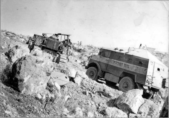 and the adjacent monastery would control the road and the water pumping station in the area. They would control all supply and access to Jerusalem, the heart of the country. Fierce battles took place, lives were lost, and ultimately Israel did not win out. In order to supply Jerusalem, a back road, the Burma Road was built during the war.
What was confusing to me when looking out over the roads and structures as they exist today, and comparing this to maps was that the road seems to have changed paths. Today, the road is on the east of the fort and monastery, but according to maps and documents and maps from 1948, the situation then seems to have been exactly opposite.
While trying to clear up this discrepancy, I discovered that, indeed, this was the case. During the British mandate, the main road from Jaffa to Jerusalem followed the path of Nahal Nachshon in this area, going to the west of the buildings. During the period between 1948 and 1967, however, this road was out of commission, sitting in Jordanian territory. The Jordanians who wanted to reach Jerusalem went via Ramallah. Israelis desiring to reach Jerusalem went through a road system which is now broken up into Rt. 44 and Rt. 38 to Shaar HaGai, and only then on Rt. 1.
During this same time period, a separate road system was built from Tel Aviv-Jaffa to Lydda airport. This road follows the path of Nahal Ayalon, as it does today, forming the western part of Route 1. After the Six Day War, the road to the airport was extended to connect to Rt. 1 and Jerusalem at Shaar HaGai. During this time, instead of going on the west side of the fort and the monastery, it was more direct to build the road to the east, where it sits today.
Once I realized that the “original” Rt. 1 should be to the west of the monastery, I got into my jeep to check it out. Shortly after passing the turn to the monastery, one continues on a hardly developed dirt road. Not more than 50 m past the pavement, you see clearly the British curb markers of the original 1948 Rt. 1! Fabulous! I found the not-quite-yellow, not-quite-brick Roman/Crusader/Ottoman/British road!

Leave a comment